
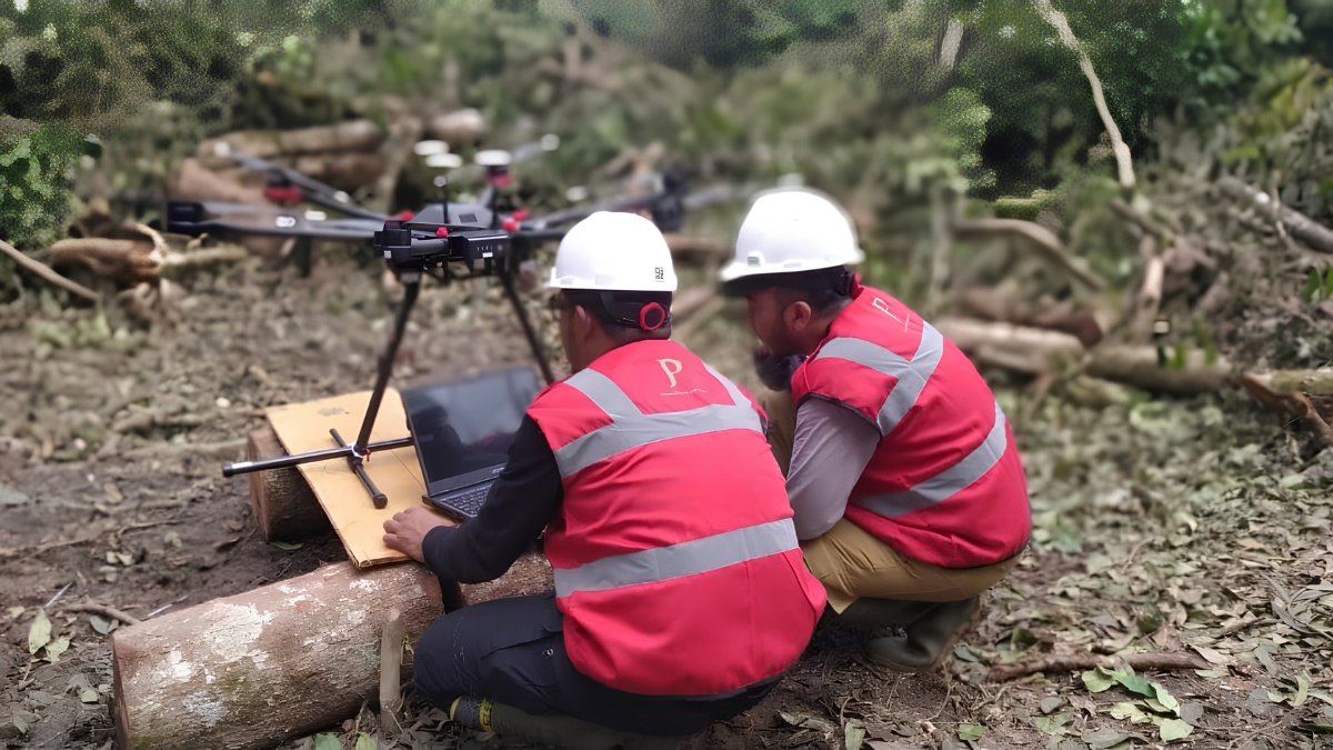
The global demand for critical minerals, precious metals, and energy transition materials has placed unprecedented pressure on exploration teams to locate hidden ore bodies faster, safer, and with higher precision than ever before. For decades, geophysics relied on two primary methods for magnetic mapping: high-altitude manned aircraft flights and labor-intensive ground walkovers. While manned aeromagnetic surveys cover immense regional territories, their high flight altitude often smooths out subtle, shallow structural targets. On the other hand, traditional ground magnetics offer exceptional detail but are severely hampered by dangerous topography, dense jungle canopy, and slow daily progression.
Enter the Drone Magnetic Survey a modern geophysical methodology that bridges the gap between regional airborne reconnaissance and localized ground surveys. By pairing high-sensitivity magnetometers with autonomous Unmanned Aerial Vehicles (UAVs), exploration teams can now collect ultra-high-resolution magnetic data at low flight altitudes with zero risk to flight crews. As mineral deposits become harder to find beneath thick overburden and dense vegetation, understanding how a Drone Magnetic Survey works and why it has become an indispensable tool in modern mineral exploration is essential for exploration managers and mining executives worldwide.
Understanding the Fundamentals: What Is a Drone Magnetic Survey?
A Drone Magnetic Survey (also referred to as UAV aeromagnetometry) is a non-invasive geophysical exploration technique that utilizes an autonomous or semi-autonomous drone to measure minute spatial variations in the Earth’s natural magnetic field. Earth’s magnetic field interacts with crustal rocks and mineral formations in different ways based on their unique magnetic susceptibility a physical property determined largely by the presence of ferromagnetic minerals such as magnetite, pyrrhotite, and ilmenite.
When a specialized UAV flies a grid pattern over a prospective target area, its onboard or towed sensors record continuous, high-frequency measurements of magnetic field intensity. Geoscientists process these readings to produce detailed magnetic contour maps, analytical signal grids, and derivative models. These maps expose subsurface geological boundaries, structural faults, intrusive stocks, shear zones, and mineralized bodies that would otherwise remain completely invisible from the surface.
A complete, field-ready Drone Magnetic Survey system integrates several advanced technological components working in unison:
- UAV Aerial Platform: Multirotor drones are commonly chosen for complex terrain and high-resolution prospect-scale mapping due to their ability to hover, maneuver precisely, and follow steep topography. For larger regional concessions, long-range fixed-wing or Vertical Take-Off and Landing (VTOL) UAVs are deployed to cover extensive line kilometers efficiently.
- High-Sensitivity Geophysical Payload: The magnetometer is the core sensing component of a Drone Magnetic Survey, capturing variations in the Earth’s magnetic field that can be used to investigate geological structures and magnetic anomalies. PTPJ supports its survey operations with SENSYS magnetometer systems, including the SENSYS R3, SENSYS BaseMAG, and GemSys 19T, providing the equipment needed for magnetic data acquisition and base-station monitoring during mineral exploration and geological mapping.
- Dynamic Noise Mitigation Mechanisms: Electric drone motors, onboard battery systems, and electronic speed controllers generate significant electromagnetic interference (EMI). To isolate the magnetometer from this noise, sensors are either suspended below the drone on a non-magnetic tow cable (a “towed bird” setup ranging from 2 to 5 meters) or mounted on a rigid, lightweight tail boom extending far from the airframe.
- Precision Positioning and Terrain-Following Systems: To capture accurate spatial data, the platform relies on Real-Time Kinematic (RTK) GPS units providing centimeter-level horizontal positioning. Crucially, real-time altimetry systems using radar or LiDAR allow the drone to maintain a consistent altitude above ground level (AGL) typically between 5 and 30 meters even while traversing steep ridges, deep valleys, and dense forest canopies.
How UAV Technology Is Transforming Mineral Exploration Workflows
The integration of autonomous drone technology into geophysical exploration represents a major technological jump forward. By fundamentally altering how aeromagnetic data is gathered, a Drone Magnetic Survey overcomes the traditional limitations of cost, speed, safety, and spatial resolution.
1. Unprecedented Spatial Resolution at Low Altitudes
In magnetic geophysics, the strength and spatial resolution of a magnetic anomaly obey the inverse-square law relative to the distance between the sensor and the magnetic source body. Manned aircraft generally fly at safe altitudes between 80 and 200 meters above ground level with line spacings of 100 to 400 meters. At these distances, high-frequency magnetic anomalies caused by narrow mineralized veins or subtle structural contacts blend into a smoothed background signal.
Conversely, a Drone Magnetic Survey operates at ultra-low altitudes of 5 to 30 meters above ground level with tight flight line spacings of 5 to 50 meters. This proximity captures high-frequency magnetic signals with incredible clarity, revealing target geometries and structural features that legacy airborne data misses completely.
| Survey Parameter | Ground Walkover Survey | Manned Aircraft Survey | Drone (UAV) Magnetic Survey |
| Flight Altitude (AGL) | 1.5 – 2.0 meters (sensor height) | 80 – 200+ meters | 5 – 50 meters |
| Line Spacing | 5 – 25 meters | 100 – 400 meters | 5 – 50 meters |
| Spatial Resolution | Ultra-High (Prospect Scale) | Low to Moderate (Regional Scale) | High to Ultra-High |
| Daily Productivity | 5 – 15 line-km / day | 500 – 2,000+ line-km / day | 50 – 200 line-km / day |
| Terrain Accessibility | Limited by cliffs, swamps, vegetation | Good, limited by flight safety regulations | Exceptional in rugged & unsafe terrain |
| Safety Risk Profile | Physical injury, wildlife hazards | Low-level aviation hazards | Zero human flight risk |
2. Unlocking Access to Remote, Rugged, and Dangerous Terrains
Mineral exploration frequently takes place in challenging environments steep mountain ranges, active volcanic zones, dense tropical rainforests, and swampy wetlands. Ground crews attempting magnetic walkovers in such terrain face severe physical hazards, dense vegetation that requires line cutting, and slow progress. Manned aircraft pilots facing dangerous downdrafts and tight valleys cannot safely maintain low terrain clearance.
A modern Drone Magnetic Survey removes human crews from dangerous terrain while maintaining optimal flight heights through automated terrain-following algorithms. Drones easily traverse impassable rivers, cliffs, and thick canopy, ensuring complete, uniform data coverage across the entire concession without damaging the natural environment or requiring ground-clearing permits.
3. Accelerated Project Timelines and Cost Optimization
Time to discovery is a vital metric for mining exploration companies. A standard ground magnetic team might cover 5 to 15 line-kilometers per day under favorable conditions, meaning a comprehensive prospect survey can take months to complete. A single UAV flight crew conducting a Drone Magnetic Survey can readily complete 50 to 200 line-kilometers in a single day.
By accelerating data acquisition by up to ten times compared to ground teams, exploration programs can process, interpret, and act upon geophysical results in near real time. Mobilization costs are also significantly lower than those associated with chartering fixed-wing planes or helicopters, making advanced geophysics accessible to early-stage junior explorers and major mining houses alike.
Geological Applications: From Direct Ore Mapping to Subsurface Structure Modeling
The versatility of a Drone Magnetic Survey lies in its ability to assist in both direct target detection and indirect structural mapping across a wide spectrum of deposit types.
Direct Magnetic Ore Body Mapping
For economic deposits rich in magnetic minerals, the raw total magnetic intensity data directly defines the subsurface boundary of the ore body:
- Iron Ore & Banded Iron Formations (BIFs): BIFs and magnetite skarns produce intense magnetic highs that stand out sharply against host sedimentary or igneous rocks, allowing precise boundary mapping.
- Magmatic Nickel-Copper-PGM Sulfides: These deposits are commonly associated with massive pyrrhotite mineralization, which creates strong localized magnetic signatures.
- Kimberlite Pipes: Diamond-bearing kimberlites intrude into host rocks, often creating distinct circular or elliptical magnetic anomalies that UAV magnetometry can map rapidly.
Indirect Structural and Hydrothermal Alteration Mapping
Many valuable commodities including epithermal gold, porphyry copper, silver, and lithium are not inherently magnetic. However, a Drone Magnetic Survey plays a pivotal role in locating them indirectly by highlighting structural pathways and alteration signatures. Faults, shear zones, and fracture networks often appear as linear magnetic lineaments or abrupt truncations in magnetic fabric. Hydrothermal fluids utilize these structural corridors to deposit precious metals.
Furthermore, magnetite-destructive alteration such as phyllic or argillic alteration in porphyry copper and epithermal systems converts magnetic magnetite into non-magnetic pyrite or hematite. This process leaves clear “magnetic lows” on high-resolution UAV survey maps, pinpointing hydrothermal cores. Potassic alteration zones near the center of porphyry deposits often form distinct magnetic highs surrounded by alteration halos displaying magnetic lows, allowing high-resolution drone mapping to resolve these subtle zonation patterns with clarity.
Advanced 3D Magnetic Inversion and Precision Drill Targeting
Data collected during a Drone Magnetic Survey is densely sampled and precisely georeferenced, making it ideal for advanced mathematical processing. Geophysicists apply 3D magnetic inversion algorithms to convert surface magnetic readings into three-dimensional voxel models of subsurface magnetic susceptibility.
These 3D models allow geologists to visualize the depth, dip, plunge, and volume of target bodies prior to drilling. By constraining drill hole placement with high-confidence 3D geophysical targets, mining companies eliminate wasteful exploratory drilling, maximize success rates, and drastically reduce overall discovery costs per ounce or ton of metal.
Overcoming Technical Challenges in Drone Aeromagnetometry
While the advantages of drone magnetometry are clear, executing a reliable survey requires overcoming distinct technical hurdles:
- Sensor Separation and EMI Compensation: Isolating the delicate magnetometer from electrical noise generated by the drone requires engineered suspension rigs and calibration routines. Dynamic figure-of-merit flight tests are executed to quantify and mathematically remove platform-induced noise.
- Diurnal Variation Removal: Earth’s magnetic field fluctuates throughout the day due to solar activity. To ensure data integrity, a synchronized, stationary base station magnetometer must be set up nearby to continuously monitor and subtract diurnal variations from the airborne dataset.
- Regulatory Compliance: Operating UAVs in remote or complex airspace requires strict adherence to local civil aviation guidelines, including Beyond Visual Line of Sight permits and stringent flight safety management systems.
Why Partnering with Experts Matters: Puncakbaru Jayatama’s Approach
Capitalizing on the full potential of a Drone Magnetic Survey involves much more than operating a drone. Reliable exploration results depend on appropriate survey planning, experienced field crews, high-quality instrumentation, rigorous data processing, and the ability to translate magnetic responses into meaningful geological interpretations. This combination of field and technical expertise is where PT Puncakbaru Jayatama (PTPJ) brings value to mineral exploration projects.
Established in 1991, Puncakbaru Jayatama has more than three decades of experience supporting mineral consulting and geophysical exploration projects in Indonesia and international exploration markets. The company’s exploration experience includes involvement in projects associated with nearly 9 million ounces of gold discoveries, including the Gosowong Gold Mine. This background allows PTPJ to combine established exploration practices with modern geophysical technology.
PTPJ’s geophysics division provides end-to-end Drone Magnetic Survey services for mineral exploration and geological mapping. High-resolution magnetic data can help identify magnetic anomalies, structural features, lithological boundaries, and geological contacts that may be important for exploration targeting and, where relevant, geotechnical site evaluation. Depending on project requirements, the survey workflow can include survey design, terrain-aware flight planning, field data acquisition, base-station monitoring, data processing and QA/QC, interpretation, and 3D geological modeling.
Hardware Supporting Our Drone Magnetic Survey Services
To support reliable magnetic data acquisition, PTPJ utilizes specialized geophysical hardware, including the GemSys 19T, SENSYS R3, and SENSYS BaseMAG systems. These instruments support the collection and monitoring of magnetic field data during survey operations, helping the team maintain data quality throughout the acquisition process.
The combination of appropriate instrumentation, experienced field operations, and professional geophysical interpretation allows PTPJ to turn high-resolution magnetic measurements into useful geological information that can support exploration targeting and subsequent drilling decisions.
Frequently Asked Questions (FAQ)
Q1: How deep can a Drone Magnetic Survey detect subsurface mineral targets?
The depth penetration of a Drone Magnetic Survey depends on the size, physical geometry, and magnetic contrast of the target relative to the surrounding rock. Large magnetic structures or major intrusive bodies can be detected at depths exceeding 500 meters to 1 kilometer, while smaller, low-contrast targets are typically resolved within the top 50 to 200 meters. The low flight altitude of UAVs significantly improves depth sensitivity compared to high-altitude manned flights.
Q2: What is the main difference between a Drone Magnetic Survey and a traditional manned aeromagnetic survey?
The primary differences lie in altitude, spatial resolution, cost, and safety. Manned surveys fly higher (80–200+ meters) and cover large regional grids efficiently, but lack detail for prospect-scale targeting. A Drone Magnetic Survey flies much lower (5–50 meters AGL), producing ultra-high-resolution data ideal for detailed structural mapping and drill targeting without placing pilots in low-altitude flight hazards.
Q3: Can a Drone Magnetic Survey identify non-magnetic minerals like gold or lithium?
Yes, through indirect structural and alteration mapping. While native gold and lithium minerals are non-magnetic, gold mineralization is frequently hosted within fault zones, shear corridors, or magnetite-destructive alteration halos. By accurately mapping these geological controls, a Drone Magnetic Survey pinpoints high-probability target zones for non-magnetic mineralization.
Q4: How does Puncakbaru Jayatama ensure data accuracy in severe topography?
PT Puncakbaru Jayatama utilizes advanced UAV platforms equipped with real-time LiDAR/radar terrain-following sensors and RTK-GPS systems. This allows the drone to automatically adjust its flight height to maintain a constant altitude above uneven terrain, ensuring smooth, high-quality magnetic data acquisition even over steep ridges and deep valleys.
Conclusion
The mineral exploration landscape is undergoing a rapid evolution, driven by the need to find deeper, more complex ore deposits under cover. The Drone Magnetic Survey has established itself as a cornerstone technology in this modern toolkit delivering ground-level spatial resolution with airborne speed, superior safety, and unmatched cost efficiency. Whether mapping magnetite-rich ore bodies directly or delineating structural pathways for precious metals, low-altitude UAV aeromagnetometry provides the spatial clarity required to make high-stakes exploration decisions with confidence.
Accelerate Your Exploration Success with Puncakbaru Jayatama
Ready to unlock the full potential of your mineral exploration assets? Partner with PT Puncakbaru Jayatama (PTPJ) Indonesia’s trusted mineral consulting and geophysics pioneer with over 30 years of proven discovery success.
Contact our expert geophysics team today to design a high-resolution Drone Magnetic Survey tailored to your concession’s unique geological setting and turn complex geophysical data into actionable drill targets.