
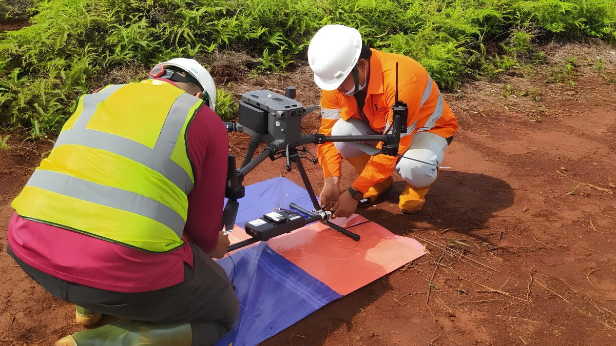
A Drone Magnetic Survey is a geophysical method that uses an unmanned aerial vehicle (UAV) to carry a magnetometer across a planned survey area. By measuring variations in the Earth’s magnetic field, the survey can provide information that contributes to geological mapping, structural interpretation, and mineral exploration.
As UAV technology has developed, drone-based magnetometry has become an option for projects where detailed magnetic data are required over relatively localized areas. However, the accuracy of a survey does not depend on the drone or magnetometer alone. Sensor characteristics, positioning, flight conditions, platform-related interference, survey design, calibration, and data processing can all influence the quality of the final dataset.
This raises an important question for exploration teams: How accurate are Drone Magnetic Surveys, and what factors determine whether the resulting data are useful for geological interpretation?
Understanding these factors is important when deciding whether UAV magnetometry is appropriate for a particular exploration objective.
Accuracy, Precision, Sensitivity, and Resolution in Drone Magnetometry
The terms accuracy, precision, sensitivity, and resolution are sometimes used interchangeably when discussing geophysical surveys, but they describe different characteristics. Accuracy generally refers to how closely a measurement represents the actual value of the quantity being measured. Precision describes the consistency or repeatability of measurements. Sensitivity refers to a sensor’s ability to detect small changes in the magnetic field, while spatial resolution relates to how effectively variations can be distinguished across the survey area.
A highly sensitive magnetometer does not automatically produce an accurate or geologically useful survey. The quality of the final dataset also depends on how the sensor is integrated with the UAV, how the aircraft is positioned and flown, the survey line spacing, environmental conditions, and the methods used to process and validate the data. Professional magnetometers used in airborne geophysics can provide high sensitivity to variations in the Earth’s magnetic field. When combined with appropriate sampling rates and survey spacing, this can produce a dense dataset suitable for detailed magnetic mapping.
However, greater data density should not automatically be interpreted as greater geological accuracy. The appropriate level of detail depends on the size, depth, and magnetic properties of the geological features being investigated.
How Survey Altitude Influences Magnetic Data
One of the characteristics that distinguishes many drone magnetic surveys from conventional airborne surveys is the potential for lower survey altitude. Operating a magnetometer closer to the ground can increase the strength and spatial detail of magnetic signals from relatively shallow sources. This can be useful when the objective is to investigate localized geological features.
The relationship between sensor altitude and magnetic response is not, however, a simple measure of survey accuracy. Magnetic anomalies are influenced by the depth, size, geometry, and magnetic properties of their sources. A lower-altitude survey can provide greater spatial detail, but it does not automatically identify every geological feature or produce a more accurate interpretation.
Conventional manned airborne surveys generally operate at different altitudes and may use different line spacings and survey configurations. Their datasets can therefore be appropriate for different exploration objectives, particularly where extensive regional coverage is required. The important consideration is how the survey altitude, line spacing, sensor characteristics, and geological target work together.
What Can Affect the Accuracy of a Drone Magnetic Survey?
A Drone Magnetic Survey involves more than carrying a magnetometer on a UAV. Several factors can affect the quality and reliability of the measurements.
Platform-Related Magnetic Interference
UAVs contain motors, electronic speed controllers, batteries, wiring, and other components that can generate magnetic effects. If the magnetometer is positioned too close to these components, the platform’s magnetic signature can interfere with measurements. This is why sensor placement and mechanical isolation are important considerations in UAV magnetometry. Systems may use suspended or towed sensor configurations to increase the distance between the magnetometer and the aircraft.
Pre-survey testing can also help identify the magnetic response of the UAV during different flight conditions. The resulting information can be incorporated into processing and compensation procedures.
Sensor Motion
A suspended magnetometer can move relative to the aircraft during turbulence, turns, acceleration, or other changes in flight conditions. Such motion can introduce variations into the measurements that are unrelated to the underlying geology. Survey planning and appropriate flight procedures can help reduce these effects. Data processing can also be used to identify measurements affected by excessive movement or other operational conditions.
Diurnal Magnetic Variations
The Earth’s magnetic field changes over time. Solar activity and ionospheric currents can cause short-term variations that may affect magnetic measurements during a survey. A stationary magnetic base station can be used to record these temporal changes while the UAV is operating. The base station data can then be used during processing to account for relevant diurnal variations.
This type of correction is an important part of magnetic survey quality control because it helps distinguish temporal changes in the Earth’s magnetic field from spatial variations associated with the geology.
Positioning and Survey Geometry
Magnetic measurements are only useful for mapping if their locations are known accurately. Positioning systems such as RTK-GNSS can improve the spatial accuracy of UAV flight paths and measurement locations. Accurate positioning is particularly important when magnetic data are integrated with geological maps, geochemical results, drilling information, or other geophysical datasets. However, positioning accuracy depends on the equipment, correction source, satellite conditions, terrain, and survey procedures. It should therefore be treated as one component of overall survey quality rather than as a guarantee of perfect spatial accuracy.
QA/QC in Drone Magnetic Surveys
Quality Assurance and Quality Control (QA/QC) are important throughout the survey process, from planning and equipment preparation to acquisition, processing, and final interpretation. One component may involve testing the magnetic characteristics of the UAV and sensor configuration before data collection. Figure-of-Merit (FOM) testing, for example, can be used to evaluate platform-related magnetic effects during controlled flight manoeuvres.
The purpose of this testing is to understand how aircraft movements and operating conditions affect the magnetometer. This information can then support appropriate compensation and processing procedures. A magnetic base station can also be used to record changes in the Earth’s magnetic field during the survey. Comparing base station observations with airborne measurements can help identify and correct relevant temporal variations.
Positioning data should also be checked as part of the survey QA/QC process. Flight path deviations, gaps in coverage, altitude variations, and other acquisition issues may need to be identified before the dataset is considered suitable for interpretation. The exact QA/QC procedures will depend on the equipment, survey specifications, geological environment, and project requirements.
What Does High-Resolution Magnetic Data Tell You?
A high-resolution magnetic dataset can provide additional detail about variations in magnetic properties across a survey area. Depending on the geological setting, these variations may contribute to the interpretation of:
- Lithological boundaries
- Geological structures
- Faults and contacts
- Magnetic bodies
- Alteration-related magnetic changes
- Regional or prospect-scale magnetic patterns
The usefulness of a magnetic anomaly depends on its geological context. A magnetic high or low does not automatically represent a mineral deposit, and a lack of a strong magnetic response does not necessarily mean that an area has no exploration potential. For this reason, magnetic interpretation is generally more useful when combined with other available geological and exploration information.
Applications of Drone Magnetic Surveys
Drone magnetometry can be applied across several areas of geophysical investigation, particularly where detailed magnetic mapping is required.
Mineral Exploration
In mineral exploration, magnetic data can help characterize the magnetic properties of rocks and identify geological contrasts that may be relevant to exploration. Some mineral deposits or host rocks have strong magnetic responses, while others may be associated with geological processes that alter the magnetic properties of surrounding rocks. For example, changes in magnetite content associated with alteration can produce magnetic contrasts. In other settings, magnetic data may help map structures or lithological contacts that provide geological context for mineralization.
The interpretation depends heavily on the local geology. Magnetic data should therefore be considered alongside geological mapping, geochemistry, drilling, and other geophysical methods where appropriate.
Archaeological Investigations
Magnetic surveys can also be used in archaeological investigations to identify buried features that have different magnetic properties from their surroundings. Depending on the site and target, these may include foundations, fired materials, ditches, or other subsurface features. UAV-based acquisition can provide an alternative approach for collecting magnetic data over selected areas, although suitability depends on site conditions, vegetation, terrain, and the required survey resolution.
Infrastructure and Site Investigations
Magnetic surveys can also contribute to investigations involving ferrous objects or infrastructure. Potential applications include locating buried metallic objects, investigating certain types of buried infrastructure, or mapping magnetic features associated with developed areas. The suitability of a drone-based approach depends on the size and depth of the target, surrounding interference, site accessibility, and applicable operational requirements.
How Deep Can a Drone Magnetic Survey Detect a Target?
There is no single maximum detection depth for a Drone Magnetic Survey. Detectability depends on several characteristics of the source, including its size, geometry, depth, magnetic susceptibility or magnetization, and contrast with the surrounding geological material. Large and strongly magnetic bodies may produce detectable anomalies at greater depths than small or weakly magnetic sources.
As the source becomes deeper or its magnetic contrast decreases, its anomaly may become more difficult to distinguish from background magnetic variations and other sources of noise. Survey altitude, line spacing, sensor sensitivity, data quality, and processing also influence how effectively a magnetic source can be characterized. For this reason, a fixed depth range should not be treated as a standard capability of every drone magnetic survey. Depth interpretation should instead be evaluated based on the specific geological setting and survey dataset.
Does the Drone’s Electrical System Interfere With the Magnetometer?
It can.
UAV motors, batteries, wiring, electronic components, and other systems can produce magnetic effects that may influence sensitive magnetometers. This is one reason professional UAV magnetic systems may use sensor suspension or towed configurations to increase separation between the sensor and the aircraft. Pre-survey testing, appropriate flight procedures, and data processing can also help identify and reduce platform-related effects.
The degree of interference depends on the UAV, sensor, configuration, flight conditions, and survey procedures. It should therefore be assessed as part of the survey design and QA/QC process.
Why Does High Resolution Matter for Exploration?
Higher spatial resolution can provide more detailed information about magnetic variations across a prospect. This may be useful when exploration teams are investigating relatively localized structures, contacts, or magnetic bodies. However, resolution should be considered in relation to the geological target. Collecting increasingly dense data does not necessarily produce a proportionally better exploration outcome.
Magnetic information is typically one component of a broader interpretation workflow. Where appropriate, it can be integrated with geological, geochemical, drilling, and other geophysical information to support exploration target evaluation. Three-dimensional magnetic inversion may also be used in some projects to investigate possible source distributions beneath the survey area. Such models are interpretations rather than direct images of the subsurface, and their reliability depends on the quality of the input data and the assumptions used in the inversion.
Is a Drone Magnetic Survey Faster Than a Ground Survey?
A UAV can cover an area without requiring personnel to physically walk every survey line, which can be useful in some environments. However, production rates vary considerably. Factors such as UAV type, flight speed, line spacing, terrain, weather, battery capacity, take-off and landing requirements, airspace restrictions, and field logistics all affect daily production.
It is therefore not appropriate to assign a single production rate to every Drone Magnetic Survey. The most suitable comparison should consider the total time required for mobilization, acquisition, data quality checks, processing, and any required field verification.
Choosing a Drone Magnetic Survey for an Exploration Project
A Drone Magnetic Survey may be worth considering when an exploration team requires detailed magnetic information over a relatively defined area. Before selecting the method, several questions should be considered:
What is the survey objective?
The required data characteristics will depend on whether the objective is regional geological mapping, prospect investigation, structural interpretation, or follow-up of an existing anomaly.
How large is the survey area?
UAV magnetics may be practical for selected smaller areas, while conventional airborne platforms may be more appropriate when extensive regional coverage is required.
What are the target characteristics?
The expected size, depth, geometry, and magnetic properties of the target can influence the appropriate survey altitude and line spacing.
What is the terrain and operating environment?
Topography, vegetation, obstacles, weather, airspace restrictions, and site access can affect UAV operations.
What existing data are available?
Regional magnetic datasets, geological maps, geochemistry, drilling information, and previous geophysical surveys can help determine what additional information is required. Considering these factors before acquisition can help ensure that the survey design is aligned with the exploration objective.
PTPJ’s Approach to Drone Magnetic Surveys
At PT Puncakbaru Jayatama (PTPJ), geophysical survey work can be approached as part of the broader exploration workflow rather than as a standalone data-acquisition exercise. For projects considering a Drone Magnetic Survey, survey planning can take into account the geological objective, survey area, terrain, expected target characteristics, required line spacing, positioning requirements, and available supporting information.
PTPJ’s geophysical services can include survey planning, data acquisition, QA/QC, processing, and interpretation. Where appropriate, magnetic results can be considered alongside other geological and geophysical information to support exploration assessment. The appropriate survey method depends on the project. In some cases, drone magnetics may be suitable; in others, conventional airborne magnetics, ground geophysics, or a combination of methods may provide more relevant information. The objective is to develop a survey approach that matches the project’s technical requirements rather than assuming that one technology is appropriate for every exploration environment.
Frequently Asked Questions
How accurate are Drone Magnetic Surveys?
Accuracy depends on the sensor, UAV configuration, positioning system, survey design, environmental conditions, calibration, flight procedures, and data processing. A well-designed survey with appropriate QA/QC can provide detailed and useful magnetic information, but accuracy should be evaluated against the specific requirements of the project.
Can a Drone Magnetic Survey detect small geological features?
Lower survey altitude and close line spacing can provide detailed spatial sampling, which may help characterize relatively localized magnetic features. Whether a particular feature can be detected depends on its size, depth, magnetic contrast, and the overall survey design.
Can drone magnetics replace ground magnetic surveys?
Not necessarily. The two methods have different operating characteristics. A drone survey can provide efficient aerial coverage in some settings, while ground magnetics may be preferable where very close sensor-to-ground measurements or specific site conditions are required.
Can drone magnetics identify a mineral deposit?
Magnetic data alone generally cannot establish the presence or economic significance of a mineral deposit. The data can contribute to geological interpretation and exploration target evaluation, but conclusions normally require integration with other geological and exploration information.
What is the main limitation of Drone Magnetic Surveys?
Potential limitations include platform-related magnetic interference, UAV flight restrictions, weather, terrain, positioning, sensor motion, survey coverage, and the inherent ambiguity of interpreting magnetic anomalies. These factors need to be considered during survey design and data processing.
Conclusion
The accuracy of a Drone Magnetic Survey depends on much more than the sensitivity of its magnetometer. Sensor characteristics, UAV configuration, positioning, flight conditions, survey altitude, line spacing, environmental magnetic variations, calibration, QA/QC, and data processing all contribute to the quality of the final dataset.
Drone magnetics can provide detailed magnetic information over selected areas and may be useful for geological mapping, structural interpretation, mineral exploration, and other applications. However, the value of the data depends on whether the survey design is appropriate for the geological question being investigated.
There is also no universal detection depth, accuracy level, production rate, or cost that applies to every UAV magnetic survey. These characteristics depend on the equipment, survey specifications, geological environment, and operating conditions. For exploration teams, the most useful approach is therefore to evaluate the survey method in the context of the project. Drone magnetics may be appropriate for some prospect-scale investigations, while conventional airborne or ground-based methods may be more suitable for other objectives.
Discuss Your Geophysical Survey Requirements With PTPJ
PT Puncakbaru Jayatama (PTPJ) provides geophysical services covering survey planning, data acquisition, quality control, processing, and interpretation.
If you are evaluating whether a Drone Magnetic Survey is appropriate for your exploration area, PTPJ can help assess the survey requirements based on your geological objectives, project scale, terrain, and available data.
Contact PTPJ to discuss your geophysical survey requirements and determine an appropriate approach for your project.