
In the high-stakes world of mineral exploration, the decision of how to map a potential prospect is rarely just about technology; it is fundamentally about return on investment. Exploration managers and mining executives are constantly balancing the need for massive regional coverage against the requirement for razor-sharp prospect targeting. When comparing traditional manned airborne magnetics with the modern Drone Magnetic Survey, the question of “value” is often misunderstood. It is not simply a matter of which service costs less per line-kilometer; it is about which method delivers the most actionable geological data, reduces drill risk, and accelerates the timeline to discovery.
For decades, manned airborne geophysics using fixed-wing aircraft or helicopters, has been the industry standard for mapping vast regional tracts. However, the rise of Unmanned Aerial Vehicles (UAVs) has introduced a disruption. A Drone Magnetic Survey offers a radically different paradigm, focusing on ultra-low-altitude resolution that legacy methods simply cannot match. To determine which method offers better value for your project, we must look beyond the price tag and analyze how each technology impacts your broader exploration strategy.
The Evolution of Aeromagnetometry: Regional vs. Prospect Scale
Traditional manned airborne surveys are the “wide-angle lens” of the exploration world. When you are tasked with exploring a new 5,000-square-kilometer concession, you need a method that can cover the ground quickly. Manned aircraft are masters of efficiency, capable of flying thousands of line-kilometers in a single day. They provide the necessary baseline to understand regional tectonic architecture, major basin structures, and large-scale lithological units. Their value lies in their speed and the ability to define broad geological frameworks that guide where exploration teams should focus their attention next.
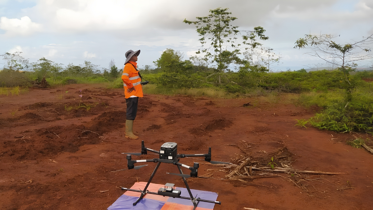
Conversely, the Drone Magnetic Survey acts as the “microscope.” It is designed for the latter stages of exploration, where the general area has already been identified, and the specific goal is to define targets for drilling. Because these drones operate at altitudes as low as 5 to 30 meters, they can resolve magnetic anomalies that are physically impossible to see from a manned aircraft flying 100 meters or more above the canopy. This shift in altitude is not just a marginal improvement; it represents a fundamental change in the quality of the data gathered.
The Value Drivers of a Drone Magnetic Survey
Why has the Drone Magnetic Survey become the fastest-growing service in modern geophysics? The value proposition is centered on three core pillars: resolution, safety, and logistical accessibility.
Unmatched Spatial Resolution
A Drone Magnetic Survey captures high-frequency anomalies that manned aircraft, trapped at higher altitudes for safety, literally smooth out. If you are hunting for narrow vein-hosted gold, specific skarn contacts, or subtle structural traps, this resolution is the difference between a high-confidence drill target and a “blind” exploration hole. In this context, the “value” of a drone survey is not the cost of the flight, but the potential savings from drilling fewer holes to make a discovery.
Safety and Terrain Accessibility
Manned aircraft face significant limitations when operating in rugged terrain. Pilots must maintain safety clearances that prevent them from hugging the terrain in mountainous regions, deep river valleys, or active volcanic zones. This gap between the terrain and the sensor creates “blind spots.” A Drone Magnetic Survey utilizes real-time LiDAR and radar terrain-following systems to automatically adjust its flight height. The drone can safely navigate steep cliffs and dense jungle, ensuring the sensor stays at a constant, low altitude relative to the ground. This capability essentially unlocks terrains that were previously considered “unmappable” or too dangerous for traditional geophysical methods.
Logistical Efficiency
Value is also found in the logistical footprint. Manned aircraft surveys require fuel depots, pilot rotations, and often the construction of remote airstrips. These are massive, capital-intensive logistical operations. A Drone Magnetic Survey can be deployed from a vehicle parked at the edge of the concession. With smaller, mobile teams, mobilization time is reduced from weeks to days, allowing exploration teams to be more agile and responsive to their findings in the field.
Comparative Analysis: Which Method Delivers ROI?
To assist in your decision-making, we have compared the fundamental characteristics of these two methods:
| Feature | Manned Airborne Survey | Drone Magnetic Survey |
| Typical Altitude | 80 to 200+ meters AGL | 5 to 30 meters AGL |
| Data Resolution | Regional/Intermediate | Ultra-High/Prospect |
| Daily Output | 500 to 2,000+ line-km | 50 to 200 line-km |
| Mobilization | Complex/High Cost | Fast/Low Cost |
| Best Use Case | Regional Reconnaissance | Targeted Drilling Prep |
Making the Decision: Mapping the Value Chain
Determining value depends entirely on your project stage. If your project is in the “greenfield” stage, covering a massive, unmapped basin where the objective is to delineate regional fault systems or major geological packages, the high-speed coverage of a manned airborne survey offers better value. You are paying for broad strokes to narrow down the search space.
However, if you have already defined a prospect, or if your target commodity is hidden in complex, high-relief terrain, the Drone Magnetic Survey offers superior value. The cost per square kilometer is lower, but more importantly, the quality of the interpretation is higher. When you combine this with the ability to perform 3D magnetic inversion modeling, which is highly effective on the dense, precise datasets produced by UAVs, you are effectively de-risking your upcoming drill program. The value proposition of a drone survey is found in the confidence it provides to the exploration geologist.
Why Puncakbaru Jayatama is Your Partner in Exploration
Understanding which method to use is only half the battle; executing the survey with precision is what makes the data useful. At PT Puncakbaru Jayatama (PTPJ), we understand that geophysics is not a commodity, it is a critical input into the economics of a mining project. With over 30 years of experience in the Indonesian and international mining sectors, we have witnessed the evolution of exploration tools firsthand.
Our geophysics division does not simply offer a drone flight. We provide an integrated solution. We start by advising you on whether a Drone Magnetic Survey is appropriate for your specific geological setting, or if a different geophysical approach is required to maximize your ROI. Our team brings deep experience in data acquisition, rigorous quality assurance, and sophisticated 3D interpretation. Whether you are navigating the complex volcanic terrains of Indonesia or exploring structured vein systems, PTPJ helps translate complex magnetic signals into actionable drill targets.
Frequently Asked Questions (FAQ)
Q1: Is a Drone Magnetic Survey always cheaper than a manned survey?
For large areas, manned surveys are often more cost-effective due to their speed. However, for prospect-scale work, a drone survey is almost always more cost-effective because it eliminates the massive mobilization and aviation costs associated with fixed-wing or helicopter operations.
Q2: Can drone magnetics replace regional airborne surveys?
No. They serve different purposes. A Drone Magnetic Survey is a surgical tool for high-resolution targeting, while regional airborne surveys are strategic tools for broad-brush reconnaissance.
Q3: How long does it take to process drone magnetic data?
Because UAV surveys are highly localized, data processing is often faster than massive regional datasets. PTPJ prioritizes rapid data turnaround, allowing your team to make decisions while still in the field.
Conclusion
The choice between a traditional airborne survey and a Drone Magnetic Survey is not about choosing the newer technology; it is about choosing the right tool for your exploration objective. By analyzing the scale of your prospect, the complexity of the terrain, and the nature of the target, you can determine which method will provide the greatest value. In the current exploration era, the flexibility, resolution, and cost-efficiency of drone-based magnetometry have made it an essential asset for any serious exploration program. When you partner with experienced consultants like Puncakbaru Jayatama, you ensure that your data is not just collected, it is translated into the discoveries that drive your business forward.
Optimize Your Exploration Strategy with Puncakbaru Jayatama
Are you unsure which geophysical survey method will deliver the best results for your upcoming campaign? Leverage over three decades of exploration expertise. Contact PT Puncakbaru Jayatama (PTPJ) today for a consultation on your geophysical needs.