Mineral exploration has become increasingly data-driven, with mining companies relying on advanced geophysical techniques to reduce exploration risk and improve drilling accuracy. Before investing in expensive drilling programs, exploration teams need a clearer understanding of what lies beneath the surface. One of the most effective methods for achieving this is a CSAMT Survey.
A CSAMT Survey (Controlled Source Audio-frequency Magnetotellurics Survey) is a geophysical exploration method used to map underground geological structures by measuring variations in electrical resistivity. The information obtained helps geologists identify potential mineralized zones, geological faults, hydrothermal alteration, and other subsurface features that may indicate valuable mineral deposits.
In Indonesia, where mineral resources are often associated with complex volcanic belts, fault systems, and tropical weathering profiles, a CSAMT Survey has become an important tool for supporting exploration programs for gold, copper, nickel, geothermal resources, and other commodities. the method helps exploration teams make better-informed decisions about where drilling should take place.
This guide explains how a CSAMT Survey works, why it is widely used in mineral exploration, and when companies should consider incorporating it into their exploration strategy.
What Is a CSAMT Survey?
A CSAMT Survey stands for Controlled Source Audio-frequency Magnetotellurics Survey, a frequency-domain electromagnetic (EM) method that uses a controlled transmitter to generate electromagnetic signals. Unlike conventional Magnetotelluric (MT) surveys that rely on naturally occurring electromagnetic fields, CSAMT creates its own signal using a grounded electrical source positioned several kilometers away from the survey area.
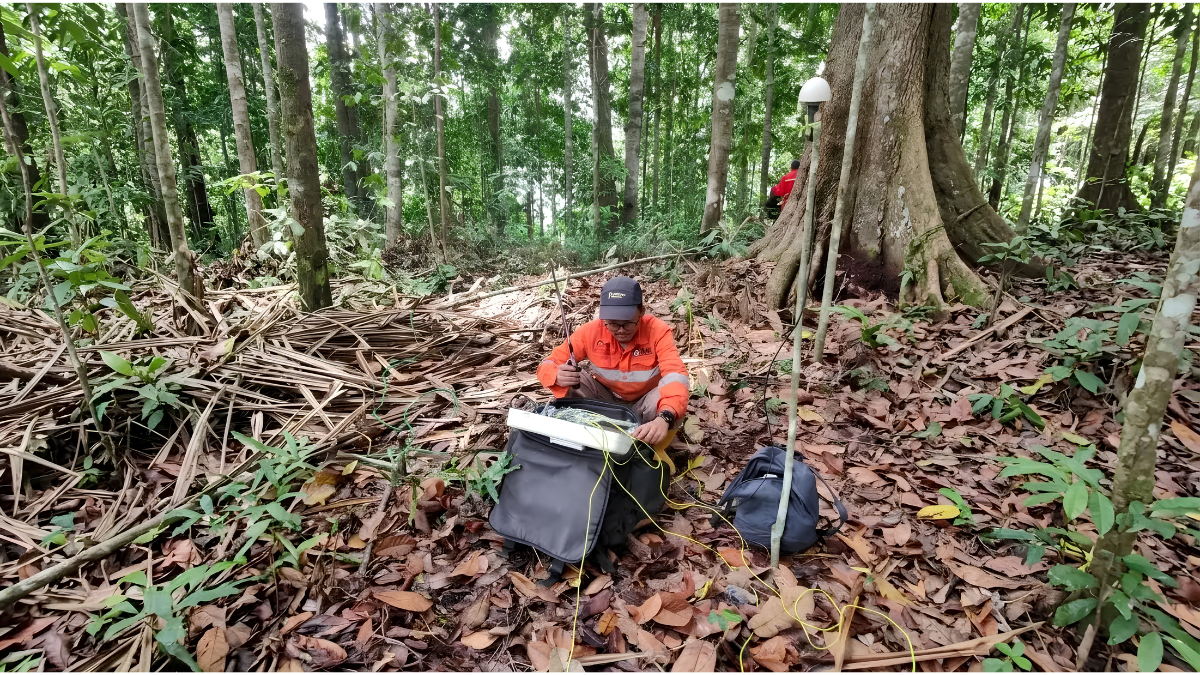
Receivers placed along the survey line measure both the electric field (E-field) and magnetic field (H-field) generated by the transmitter. By comparing these measurements, geophysicists calculate the apparent resistivity of underground materials and produce two-dimensional or three-dimensional models of the subsurface.
Because different rock types conduct electricity differently, the resulting resistivity model can reveal geological structures that may be associated with mineralization. Conductive zones may represent clay alteration, groundwater, or sulfide mineralization, while highly resistive zones often correspond to fresh intrusive rocks, quartzite, or competent bedrock.
Compared with many conventional electrical resistivity methods, a CSAMT Survey can investigate significantly greater depths, making it particularly valuable for regional-scale mineral exploration.
How Does a CSAMT Survey Work?
Although the technology behind a CSAMT Survey is sophisticated, its exploration workflow follows a logical process.
First, a long grounded transmitter wire is installed some distance away from the survey area. The transmitter generates electromagnetic waves across multiple audio frequencies, typically ranging from approximately 0.1 Hz to 10 kHz. Higher frequencies provide information about shallow subsurface conditions, while lower frequencies penetrate much deeper into the ground.
As the electromagnetic energy travels through the earth, underground materials respond differently depending on their electrical resistivity. Receivers positioned along the survey line record both the electric and magnetic fields generated during the survey.
These measurements are then processed using inversion software to create detailed resistivity sections or three-dimensional subsurface models. The final interpretation delivers a detailed subsurface resistivity model to identify geological boundaries, alteration zones, structural features, and potential mineralized targets without disturbing the ground.
Depending on survey design, geological conditions, and transmitter power, a CSAMT Survey can typically investigate depths rangingseveral hundred meters to ~1–2 km, making it suitable for both shallow and deep exploration targets.
Why Is a CSAMT Survey Important for Mineral Exploration?
Every drilling program represents a significant investment. Without reliable subsurface information, exploration companies risk drilling non-prospective locations, increasing both costs and project uncertainty.
A CSAMT Survey helps reduce this uncertainty by providing a detailed picture of underground resistivity variations before drilling begins.
Many economically important mineral deposits are associated with distinct geological structures, including:
- Fault zones
- Shear zones
- Hydrothermal alteration
- Intrusive contacts
- Sulfide-rich mineralization
- Fracture systems
Because these features often exhibit different electrical properties than surrounding rocks, they can frequently be detected through resistivity imaging.
Rather than identifying minerals directly, a CSAMT Survey identifies geological environments where mineralization is more likely to occur. Exploration teams then combine these findings with geological mapping, geochemical sampling, magnetic surveys, and drilling data to build a more complete geological model.
Why CSAMT Surveys Are Well Suited to Indonesian Exploration Projects
Indonesia presents unique geological conditions that make advanced geophysical surveys particularly valuable.
The country lies along the Pacific Ring of Fire, where tectonic activity has created extensive volcanic arcs and complex fault systems. These geological environments host many of Indonesia’s major mineral resources, including:
- Porphyry copper-gold deposits in Nusa Tenggara and Papua
- Epithermal gold systems throughout Sumatra and Java
- Nickel laterite districts in Sulawesi and Halmahera
- Geothermal systems distributed across Indonesia’s volcanic regions
Many of these deposits are structurally controlled or associated with hydrothermal alteration, both of which produce measurable resistivity contrasts.
Indonesia’s tropical climate also creates thick weathered zones that may obscure surface geological observations. A CSAMT Survey helps exploration teams image the underlying bedrock beneath weathered cover, allowing them to better understand geological structures before committing to drilling programs.
For companies operating under an IUP (Mining Business License), integrating geophysical methods such as CSAMT into exploration programs can support more efficient target generation while reducing unnecessary drilling expenditures.
What Can a CSAMT Survey Detect?
A CSAMT Survey is capable of identifying numerous subsurface features relevant to mineral exploration.
These commonly include:
- Geological faults
- Shear zones
- Hydrothermal alteration halos
- Lithological boundaries
- Fracture systems
- Conductive sulfide zones
- Groundwater-bearing structures
- Bedrock depth beneath weathered materials
It is important to understand that the survey does not directly detect specific minerals such as gold, copper, or nickel. Instead, it identifies resistivity anomalies that may indicate favorable geological conditions associated with mineral deposits.
Proper interpretation therefore requires experienced geophysicists working alongside geologists to integrate multiple datasets.
Advantages of Using a CSAMT Survey
One reason a CSAMT Survey remains widely used is its ability to balance depth, coverage, and data quality.
Compared with many alternative geophysical methods, it offers several important advantages.
It provides much deeper investigation depths than conventional electrical resistivity surveys while maintaining relatively high spatial resolution. Because the transmitter generates a controlled electromagnetic signal, survey quality is generally more reliable than natural-source methods under certain field conditions.
The method is also completely non-invasive, requiring no excavation or drilling during data acquisition. Large exploration areas can be surveyed efficiently, allowing companies to prioritize the most prospective drill targets before investing in expensive drilling campaigns.
Most importantly, a CSAMT Survey contributes valuable geological information that improves confidence during exploration planning and resource evaluation.
CSAMT Survey vs MT Survey
Although both methods measure underground resistivity, they differ in several important ways.
A traditional Magnetotelluric (MT) survey relies on naturally occurring electromagnetic fields generated by atmospheric and solar activity. Because these signals cannot be controlled, data quality may vary depending on environmental conditions.
A CSAMT Survey, on the other hand, generates its own electromagnetic source, giving survey teams much greater control over signal strength and acquisition quality.
For regional mineral exploration projects requiring detailed imaging from shallow to intermediate depths, CSAMT is often the preferred solution. MT surveys remain valuable for investigating much deeper crustal structures over regional scales.
When Should You Use a CSAMT Survey?
A CSAMT Survey is particularly valuable when exploration projects require better understanding of subsurface geology before drilling.
Companies often use the method when:
- Defining exploration targets beneath weathered cover
- Investigating fault-controlled mineral systems
- Mapping hydrothermal alteration
- Supporting porphyry and epithermal exploration
- Exploring nickel, copper, and gold prospects
- Planning deep exploration drilling
- Integrating geological, geochemical, and geophysical datasets
Rather than functioning as a standalone exploration solution, CSAMT performs best as part of an integrated exploration workflow.
How Puncakbaru Jayatama Supports Mineral Exploration
Successful exploration depends not only on advanced technology but also on accurate interpretation and integration of geological information. Magnetotelluric methods—including CSAMT, MT, and AMT—provide valuable subsurface resistivity information that can help exploration teams investigate geological conditions that cannot be observed directly from the surface.
At Puncakbaru Jayatama (PTPJ), our CSAMT Survey services use Zonge equipment for deep resistivity imaging in mineral exploration and geotechnical investigations. Depending on the survey design and project objectives, magnetotelluric methods can help map subsurface structures, fault systems, and geological boundaries at depths reaching several kilometers, providing critical information for exploration targeting as well as geotechnical and foundation design.
For mineral exploration projects, this subsurface information can help geologists better understand structural controls, alteration zones, and geological boundaries before committing to drilling. A CSAMT Survey does not directly identify a specific mineral such as gold, copper, or nickel; instead, it reveals resistivity variations that can indicate geological environments potentially associated with mineralization. As highlighted earlier in this guide, CSAMT can investigate from relatively shallow depths to approximately 1–2 km, depending on geology, transmitter power, and survey design.
Combined with geological mapping, geochemical investigations, drilling programs, and other geophysical methods, magnetotelluric data contributes to a more comprehensive exploration strategy that can improve target generation, geological interpretation, and decision-making while reducing exploration uncertainty.
Because every mineral deposit and project environment is unique, survey planning, equipment configuration, acquisition parameters, and interpretation should always be tailored to the project’s geological setting and exploration objectives. PTPJ’s approach is therefore focused not simply on acquiring geophysical data, but on generating reliable subsurface information that can support the broader exploration strategy.
Frequently Asked Questions
How deep can a CSAMT Survey investigate?
Depending on geology, transmitter power, and survey design, a CSAMT Survey can typically investigate depths ranging from several tens of meters to approximately ~1–2 km
Can a CSAMT Survey directly detect gold or copper?
No. A CSAMT Survey measures underground electrical resistivity rather than identifying specific minerals. However, it can detect geological structures and alteration zones commonly associated with mineral deposits.
Is a CSAMT Survey suitable for Indonesia?
Yes. Indonesia’s volcanic arcs, fault systems, tropical weathering profiles, and diverse mineral deposits make CSAMT Survey technology highly applicable for exploration projects across the country.
What industries use CSAMT surveys?
Besides mineral exploration, CSAMT is also widely applied in geothermal exploration, groundwater investigations, engineering geology, environmental studies, and infrastructure projects.
Is a CSAMT Survey better than drilling?
No. The two methods serve different purposes. A CSAMT Survey helps determine the most prospective locations for drilling, while drilling provides the physical samples required to confirm mineralization.
Conclusion
A CSAMT Survey has become one of the most effective geophysical methods for investigating underground geological structures in mineral exploration. By producing detailed resistivity images of the subsurface, it helps exploration teams identify structural controls, hydrothermal alteration, and other geological features that may indicate economically significant mineralization.
For Indonesia’s complex geological environment, where volcanic activity, deep weathering, and structurally controlled deposits are common, CSAMT offers valuable insights that support more efficient exploration planning and reduce drilling uncertainty.
When integrated with geological mapping, geochemical analysis, and drilling, a CSAMT Survey provides exploration companies with a stronger foundation for making informed investment decisions throughout the exploration lifecycle.
Ready to Support Your Next Exploration Project?
If your exploration program requires reliable subsurface information before drilling, Puncakbaru Jayatama (PTPJ) provides professional CSAMT Survey services tailored to Indonesia’s diverse geological conditions. Our experienced team combines advanced geophysical technology with practical exploration expertise to help clients generate better exploration targets, improve geological understanding, and support more confident project decisions.
Contact PTPJ today to learn how a CSAMT Survey can strengthen your mineral exploration strategy.